IMPRO Satellite Image Processing and Telecommunication IMPRO A.Ş is founded as a 100% SSTEK A.Ş subsidiary with the mission of becoming an Image Processing Excellence Center and providing the national and international aerial platform imagery market with the information obtained from raw or processed aerial platform imagers by using our national reconnaissance and observation satellites both core and surplus image capacities.
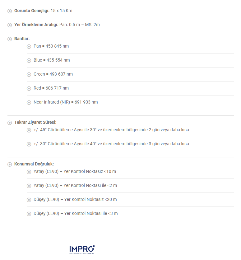
Capability Swath: 15 x 15 Km GSD – Product Resolution (at nadir): 0.5 meters in PAN; 2 meters in MS bands Bands: Pan = 450-845 nm Blue = 435-554 nm Green = 493-607 nm Red = 606-717 nm Near Infrared (NIR) = 691-933 nm Revisit Frequency: With +/- 45° viewing angle: 2 days and better above 30°latitude With +/- 30° viewing angle: 3 days and better above 40°latitude Geolocation Accuracy: Horizontal CE90 without using GCPs ≤ 10 m Horizontal CE90 with one GCP ≤ 2 m Vertical LE90 without using GCPs ≤ 20 m Vertical LE90 with one GCP ≤ 3 m
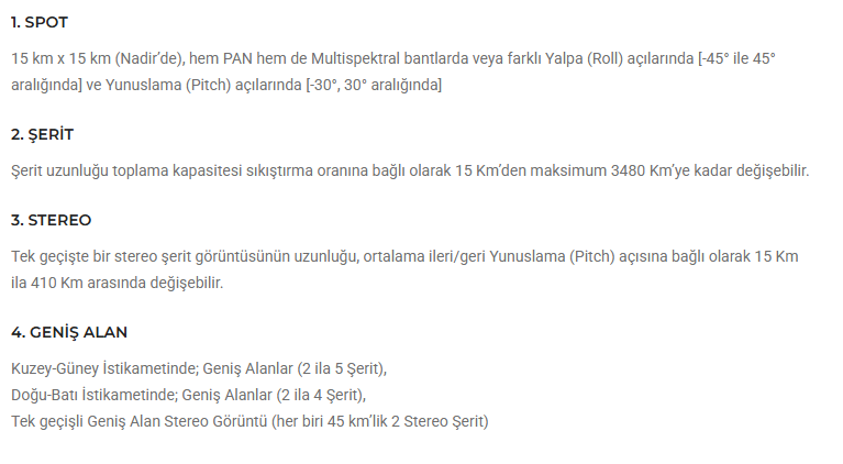
MODES 1. SPOT 15 km x 15 km at nadir, in both PAN and Multispectral bands or at different Roll and Pitch angles, within [-45°,45°] in Roll and [-30°, 30°] in Pitch. 2. STRIP The strip length acquisition capacity can vary from 15 Km to as maximum 3480 Km (depending on the compression ratio). 3. STEREO The length of a stereo strip image in single pass can vary from 15 Km to 410 Km depending on the mean fore/aft Pitch angle. 4. WIDE AREA North-South Wide Areas (2 to 5 Strip), East-West Wide Areas (2 to 4 Strip), Single-pass Wide Area Stereo Image (2 Stereo Strips of 45 km each)
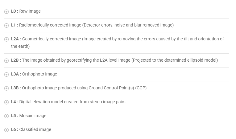
IMAGE LEVELS L0 : Raw Image L1 : Radiometrically corrected image (Detector errors, noise and blur removed image) L2A : Geometrically corrected image (Image created by removing the errors caused by the tilt and orientation of the earth) L2B : The image obtained by georectifying the L2A level image (Projected to the determined ellipsoid model) L3A : Orthophoto image L3B : Orthophoto image produced using Ground Control Point(s) (GCP) L4 : Digital elevation model created from stereo image pairs L5 : Mosaic image L6 : Classified image
Mobile Applications